County Laois: Ireland’s Most Alerted County for Severe Weather (2020–2025)
Published in The MapAlerter Blog, Nov 25th 2025
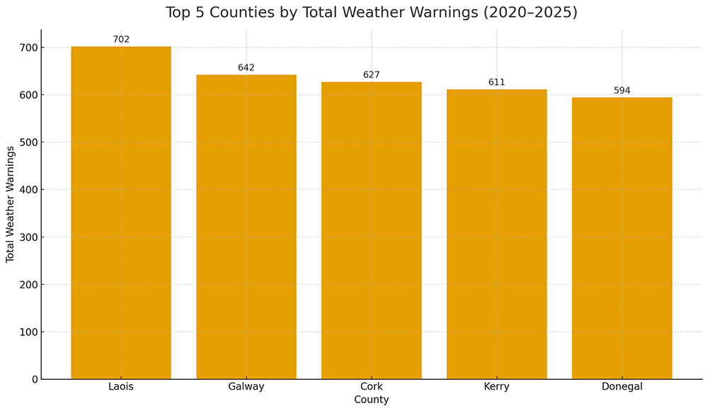
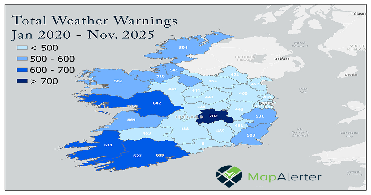
When discussions turn to severe weather risk in Ireland, attention often gravitates towards coastal counties exposed to Atlantic storms. However, a verified analysis of Met Éireann warning data from 2020 to 2025 reveals a striking and data-backed reality: County Laois is officially the most alerted county in Ireland for severe weather warnings. With a total of 702 weather warnings issued in just six years, Laois now ranks highest nationally, exceeding traditionally high-risk counties such as Galway, Cork and Kerry. This distinction is not driven by a single weather type but by persistent exposure across multiple hazard categories, positioning Laois as a critical focal point for understanding how inland counties are increasingly affected by Ireland’s evolving climate patterns. This article explores what the verified data reveals, why Laois has topped the national alert rankings, and what this means for local authorities, infrastructure managers and emergency planners.
Why Laois Tops the National Alert Rankings:
1. Central Geographic Position
Laois lies directly in the path of weather systems tracking from the Atlantic across Ireland. Storm fronts may sometimes reorganise and intensify as they move inland, placing the Midlands — and Laois in particular — under repeated warning conditions across a variety of warning categories.
2. Climatic Convergence
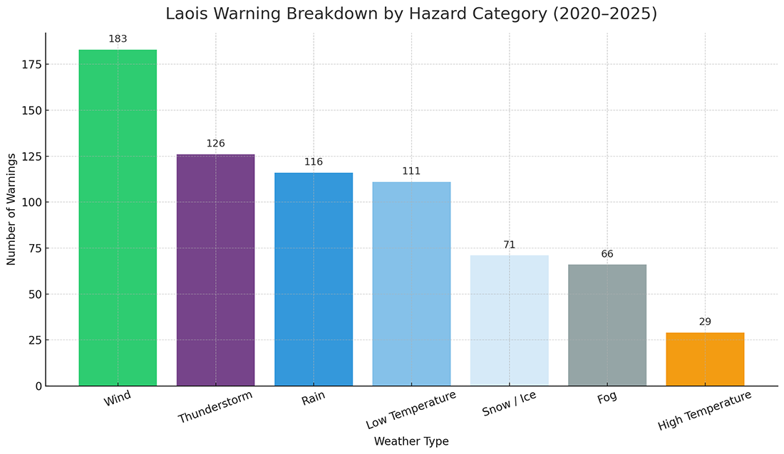
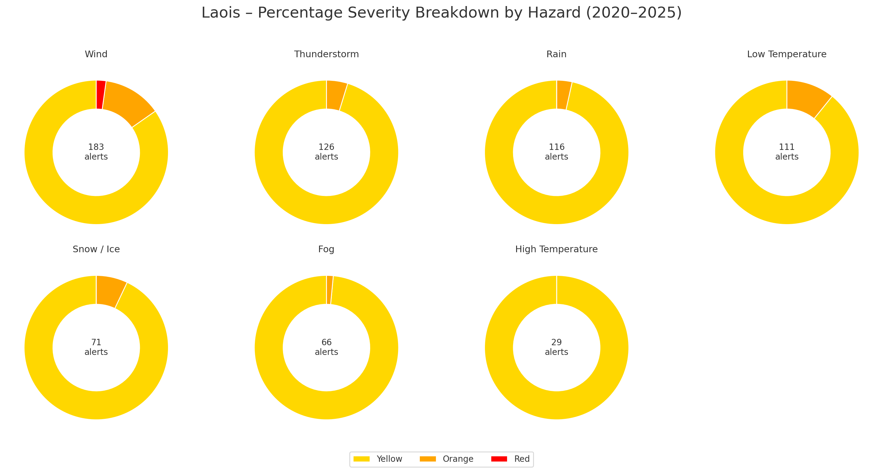
Laois experiences overlapping maritime and continental weather influences, making it vulnerable to: - Atlantic wind systems - Convective summer thunderstorms - Extended rainfall events - Frost, snow and ice during cold spells. This overlap creates near-continuous alert conditions across all seasons.
3. Landscape and Infrastructure Exposure
Open agricultural zones, transport corridors, wooded roads and dispersed rural communities contribute to environments where precautionary warnings are frequently issued to mitigate safety risks.
A Year-Round Cycle of Alerts
Unlike counties that experience short, seasonal storm peaks, Laois demonstrates a continuous warning profile throughout the year:
- Winter: Wind, low temperature, snow and ice
- Spring: Rainfall and thunderstorms
- Summer: Convective storms and heat alerts
- Autumn: Storm fronts and heavy rainfall systems
This sustained pattern places ongoing pressure on emergency response systems and critical infrastructure.
ℹ️ Did you know?
MapAlerter is used by 23 Irish local authorities as their official platform for sending severe weather alerts to local residents and busiensses? The service is completely free. All you need to do is sign up with your preferred location and you will receive SMS, email or MapAlerter app notifications for your part of the country when they are issued, if your Council is using MapAlerter. This includes instant changes to the weather warning status, fallen tree alerts, risk-of-flood warnings, and much more. MapAlerter was launched in 2011 and it has issued thousands of Council alerts during severe weather events. For active Councils using MapAlerter, this service is the only place where you can sign up for Council SMS text alerts, email warnings and app notifications when your local area is impacted during storms.
What This Means for Local Services:
The data suggests a wider operational reality for services supporting communities in Laois. Severe weather is no longer an occasional disruption, but a recurring condition shaping day-to-day resilience planning. Rather than isolated incidents, the pattern points to sustained exposure that influences how essential services, infrastructure systems and response frameworks must operate over time.
Key considerations include:
-
Higher frequency of weather-related coordination across services
-
Ongoing pressure on transport networks and maintenance programmes
-
Continued stress on power and communications infrastructure
-
Increased complexity when planning outdoor works and construction activity
-
Growing importance of clear, timely public information during evolving conditions
This trend highlights the need for a forward-looking, resilience-based approach, where preparedness, adaptability and communication are embedded into routine operations, supporting communities through increasingly variable weather patterns.
The Role of Data-Driven Alerting
Understanding Laois’ position as Ireland’s most alerted county enables more intelligent planning. Historical data allows authorities to:
- Identify peak alert patterns
- Anticipate multi-hazard overlaps
- Improve timing and clarity of public warnings
- Plan infrastructure investment with precision
- Strengthen coordination across agencies
This is where MapAlerter plays a vital role transforming raw weather data into targeted, location-based alerts and practical resilience strategies for councils and public bodies. By integrating verified warning trends into modern alert systems, Laois can shift from disruption response to proactive community protection.
From Awareness to Resilience
The designation of Laois as Ireland’s most alerted county is not merely a statistic it is a strategic warning sign. As climate volatility increases, Laois stands as a case study for how inland counties must adapt to sustained operational pressure. A data-led approach can help:
- Reduce long-term damage costs
- Improve emergency response efficiency
- Strengthen public safety outcomes
- Build long-term climate resilience
With 702 severe weather warnings between 2020 and 2025, County Laois has emerged as Ireland’s most alerted county. Facing consistent multi-hazard exposure and repeated high-severity events, weather risk in Laois is no longer episodic, it is a permanent planning reality. Counties and organisations that respond with structured preparedness, advanced alerting and proactive communication will be best equipped to protect communities, infrastructure and critical services in the years ahead.
A Word Of Appreciation For The Data Providers
Data: Copyright Met Éireann. Source: www.met.ie. This data is published under a Creative Commons Attribution 4.0 International (CC BY 4.0). https://creativecommons.org/licenses/by/4.0/.
Disclaimer: This data is published under a Creative Commons Attribution 4.0 International (CC BY 4.0). https://creativecommons.org/licenses/by/4.0/. This material has been modified from the original.
We would like to thank Met Eireann for their continuous efforts, especially during severe weather events when the situations changes rapidly. Met Eireann makes their severe weather data available under a Creative Commons 4 licence, meaning that MapAlerter can use and remix the source data to bring you reports like this. The data contained in this report is based on Met Eireann data that was received and processed by MapAlerter since January 2020.