An Analysis of Met Éireann Wind Warnings Since 2020: Why Galway Has Received Most Wind Warnings In Recent Years
Published in The MapAlerter Blog, Nov 20th 2025
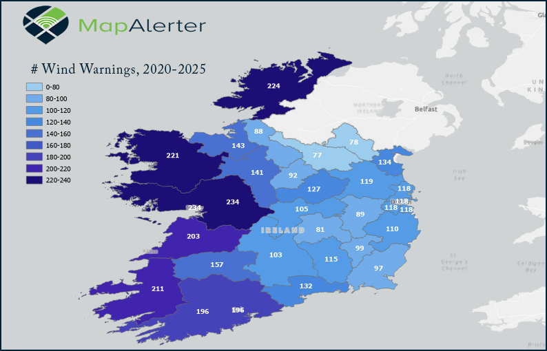
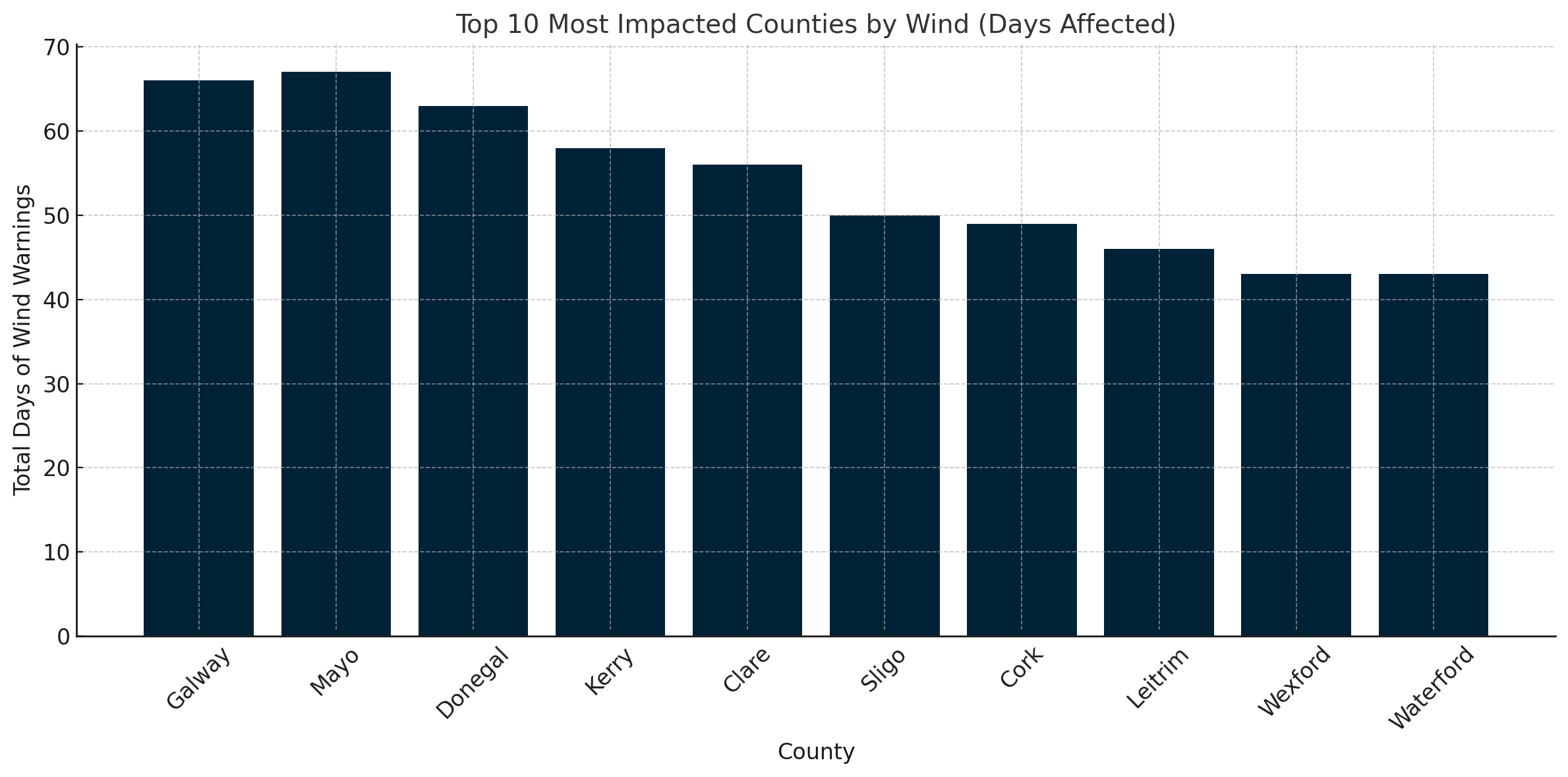
Galway has long been associated with Atlantic weather, powerful squalls and dramatic coastlines. A full analysis of Met Éireann wind warnings from January 2020 to November 2025 now confirms this reputation: Galway has been under more wind warnings than any other county since 2020. Over the past five years, Galway recorded 234 separate wind warnings, totalling 66 full days under wind alert. This places it firmly at the top of Ireland’s wind-warning league table, ahead of other Atlantic counties such as Donegal, Mayo, Kerry and Clare.
How Galway Compares to the Rest of Ireland
Western counties dominate Ireland’s wind-warning statistics. Donegal recorded 224 wind warnings, while Mayo logged 221 during the same period. These counties sit directly on the Atlantic storm track, where low-pressure systems typically make landfall. Inland and eastern counties recorded fewer wind warnings, reflecting the shelter provided by surrounding terrain and distance from the coast. One interesting anomaly is that the total amount of time under a wind warning was slightly greater in Co. Mayo (67 days) than it was in Co. Galway (66 days).
✅ - Active MapAlerter Council ❌ - Not Using MapAlerter
| County | # Wind Warnings | # Days | # Hours | Max Speed (kmph) | 🟡 | 🟠 | 🔴 | |
|---|---|---|---|---|---|---|---|---|
| 1 | 🥇 Galway✅ | 234 | 66 | 1603 | 145 | 173 | 49 | 12 |
| 2 | 🥈 Donegal✅ | 224 | 63 | 1510 | 130 | 176 | 41 | 7 |
| 3 | 🥉 Mayo✅ | 221 | 67 | 1583 | 130 | 173 | 42 | 6 |
| 4 | Kerry✅ | 211 | 58 | 1402 | 130 | 167 | 36 | 8 |
| 5 | Clare✅ | 203 | 56 | 1326 | 145 | 152 | 39 | 12 |
| 6 | Cork✅ | 196 | 52 | 1247 | 130 | 150 | 34 | 12 |
| 7 | Limerick✅ | 157 | 44 | 1055 | 130 | 123 | 22 | 12 |
| 8 | Sligo❌ | 143 | 37 | 887 | 130 | 113 | 20 | 10 |
| 9 | Roscommon✅ | 141 | 39 | 930 | 120 | 110 | 21 | 10 |
| 10 | Louth✅ | 134 | 34 | 824 | 110 | 110 | 17 | 7 |
| 11 | Waterford✅ | 132 | 35 | 837 | 120 | 100 | 21 | 11 |
| 12 | Westmeath❌ | 127 | 32 | 689 | 115 | 103 | 18 | 6 |
| 13 | Meath✅ | 119 | 29 | 645 | 110 | 93 | 19 | 7 |
| 14 | Dublin✅❌ | 118 | 27 | 634 | 110 | 95 | 16 | 7 |
| 15 | Kilkenny✅ | 115 | 27 | 631 | 110 | 92 | 16 | 7 |
| 16 | Wicklow❌ | 110 | 24 | 553 | 120 | 85 | 17 | 8 |
| 17 | Offaly❌ | 105 | 25 | 595 | 110 | 82 | 16 | 7 |
| 18 | Tipperary✅ | 103 | 24 | 580 | 110 | 81 | 14 | 8 |
| 19 | Carlow✅ | 99 | 23 | 558 | 100 | 76 | 15 | 8 |
| 20 | Wexford✅ | 97 | 22 | 528 | 105 | 74 | 15 | 8 |
| 21 | Longford✅ | 92 | 22 | 552 | 100 | 73 | 13 | 6 |
| 22 | Kildare✅ | 89 | 21 | 499 | 105 | 69 | 14 | 6 |
| 23 | Leitrim✅ | 88 | 19 | 448 | 110 | 68 | 12 | 8 |
| 24 | Laois❌ | 81 | 18 | 434 | 95 | 62 | 13 | 6 |
| 25 | Monaghan✅ | 78 | 17 | 435 | 95 | 60 | 12 | 6 |
| 26 | Cavan❌ | 77 | 17 | 402 | 94 | 60 | 14 | 3 |
✅ Active MapAlerter Council
This Council uses MapAlerter to issue severe weather and a variety of other alerts. You can sign up for a free MapAlerter account to get countywide weather warnings and localised storm issues such as fallen trees, floods and other storm hazard alerts.
MapAlerter is a completely free service that is now used by 23 Councils as their official alert service platform.
❌ This Council is not using MapAlerter
MapAlerter is a completely free service that is now used by 23 Councils as their official alert service platform. Unfortunately, this Council is not using MapAlerter.
✅❌ 2 Dublin Councils are active on MapAlerter, two are not.
MapAlerter is a completely free service that is now used by 23 Councils as their official alert service platform. The service is used by Dublin City Council and Fingal County Council not it is not used by Dun Laoghaire Rathdown County Council or South Dublin County Council.
ℹ️ Did you know?
Warning Severity in Galway
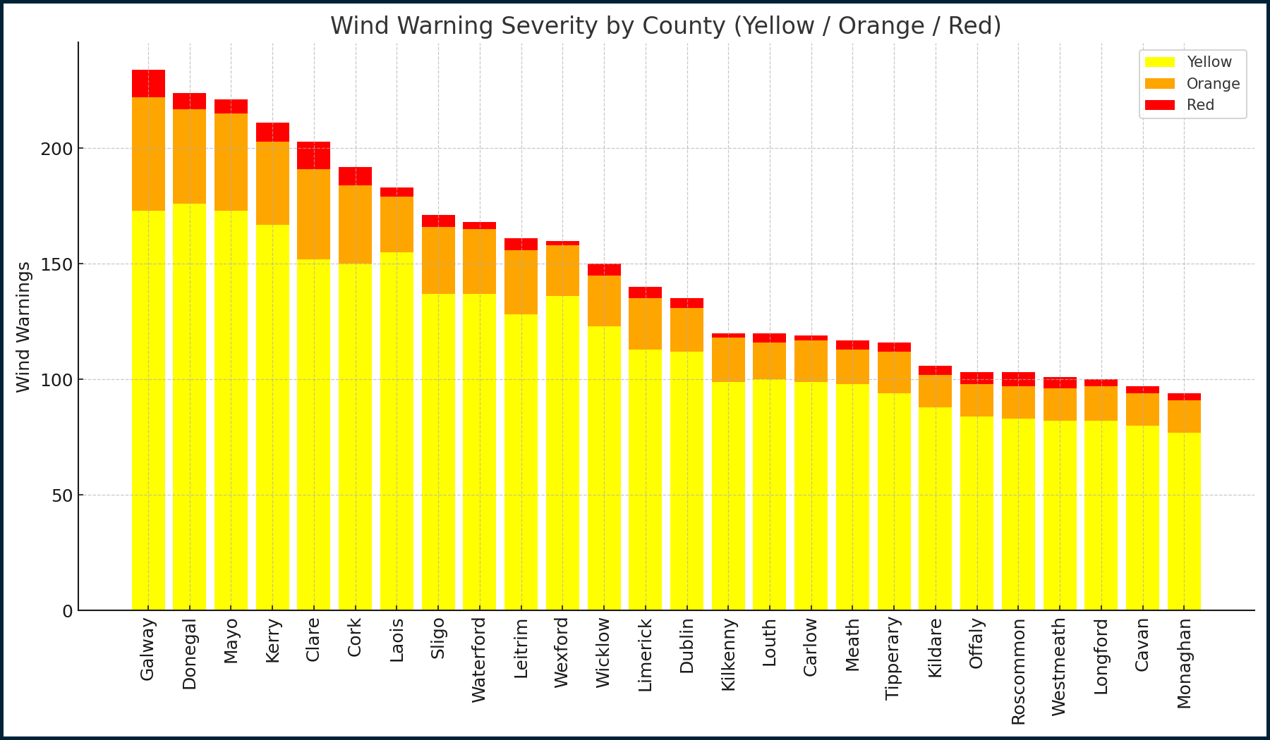
Galway’s 234 wind warnings are not all minor events. Over the near-six year period, the county experienced:
- 173 Yellow wind warnings
- 49 Orange wind warnings
- 12 Red wind warnings
This means roughly a quarter of Galway’s wind alerts fell into the more serious Orange and Red categories, where local authorities typically activate enhanced response plans for roads, coastal areas and critical infrastructure.
Storm Events and Maximum Wind Speeds
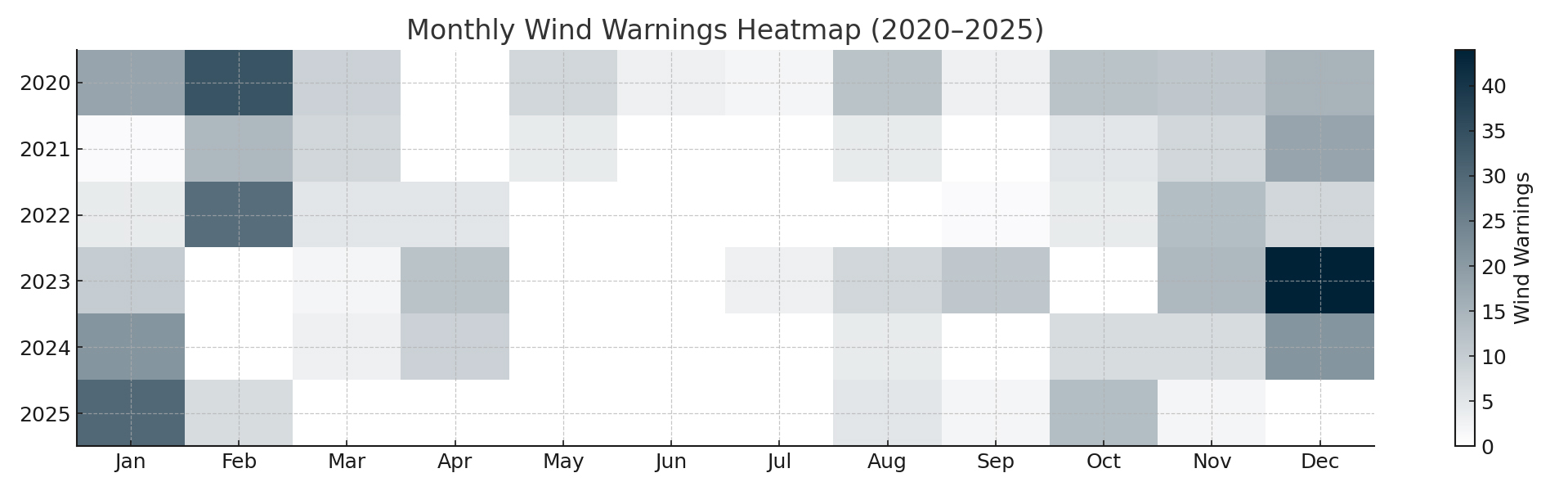
Met Éireann alert text for Galway severe weather wind warnings during this period includes references to named storms such as Storm Barra, Storm Isha, Storm Debi and Storm Eunice. These storms were expected to deliver gusts in excess of 120–145 km/h in parts of the county, according to the wind warning content issued. The maximum wind value extracted from the warning text for Galway reaches approximately 145 km/h, highlighting the intensity of the most severe events. The highest concentration of wind warnings over the past five years was December 2023:
Why Galway Is So Windy
Galway’s geography explains much of its wind profile. The county faces directly onto the Atlantic, with very little to slow incoming weather systems before they make landfall. As Met Éireann regularly notes in its forecasts, Atlantic storms “frequently bring disruptive wind gusts to western counties”.
Several simple factors are at play:
- Coastal exposure: Storms move in from the ocean and hit Galway early, often with their strongest winds.
- Open Atlantic fetch: Winds have a long distance over open water to build up strength before reaching the coast.
- Mixed terrain: Mountainous areas and valleys in the west of the county can funnel and accelerate wind locally.
- Broad bays: Features such as Galway Bay help channel strong winds inland towards more populated areas.
How Other Counties Compare
Inland counties such as Laois, Offaly and Tipperary recorded far fewer wind warnings, reflecting their more sheltered positions. They benefit from distance from the Atlantic as well as shielding from surrounding counties and higher ground. Eastern counties, including Dublin, also see fewer extreme wind events, although urban areas can still experience localised impacts such as falling branches, flying debris and disruption to transport.
Government guidance on severe weather preparedness on gov.ie emphasises the central role of local authorities in planning for these events. Councils are expected to coordinate on-the-ground responses, mobilise outdoor crews and communicate timely safety messages to the public.
Local Authorities, Engineering and Real-Time Alerts
For Galway County Council and other local authorities, this level of wind activity represents a substantial operational challenge. Road engineers, drainage teams and emergency management staff must plan for frequent high-wind episodes, including:
- Tree and vegetation management along key routes
- Inspection and maintenance of coastal defences and roadside infrastructure
- Drainage clearance ahead of major storm systems
- Deployment of crews during Red and Orange events
- Targeted public communication and road safety messaging
Advanced alerting platforms such as MapAlerter.ie support this work by turning Met Éireann warnings into targeted notifications for both council staff and residents. This helps engineering and emergency teams act quickly when conditions deteriorate, reducing disruption and improving safety.
Get Alerts For Galway
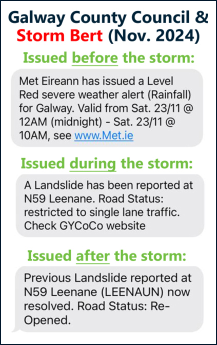
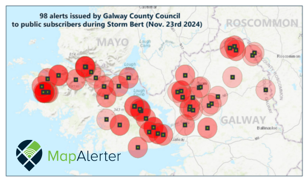
MapAlerter offers free SMS, email and app notifications from Galway County Council for localised severe weather events including fallen trees, power lines and other obstructions that might occur during storms. Apart from severe weather, MapAlerter also provides a free alert service for Galway County Council for planning applications, commencement notices, river sensor heights, bathing water quality notices, and much more. One of the busiest days for Galway County Council on Mapalerter was Storm Bert (November 2024) when they issued 98 fallen tree, flood and hazard warnings to members of the public via MapAlerter's free alert service.
No Eircode found
We couldn't find that Eircode. You can still sign up and choose your location.
We Found You!
MapAlerter issues the following alerts:
- Severe Weather
- Road Closures
- Planning Activity
- River Heights
- Bathing Water
- Agri. Alerts
- Property Sales
- Water Issues
- Public Consultations
- More...
A Word Of Appreciation For The Data Providers
Data: Copyright Met Éireann. Source: www.met.ie. This data is published under a Creative Commons Attribution 4.0 International (CC BY 4.0). https://creativecommons.org/licenses/by/4.0/. DisclaimerL This data is published under a Creative Commons Attribution 4.0 International (CC BY 4.0). https://creativecommons.org/licenses/by/4.0/. This material has been modified from the original.
We would like to thank Met Eireann for their continuous efforts, especially during severe weather events when the situations changes rapidly. Met Eireann makes their severe weather data available under a Creative Commons 4 licence, meaning that MapAlerter can use and remix the source data to bring you reports like this. The data contained in this report is based on Met Eireann data that was received and processed by MapAlerter since January 2020.
In case you are wondering about our hourly calculations, we were able to remove overlap alerts to ensure that the results were accurate. For example, if Met Eireann published a Level Yellow wind warning for Galway and then upgraded some of the impact hours to Level Orange, then we would only use the Level Orange overlap hours for our calculations. Hope that makes sense ;)
* Disclaimer re: max wind speeds:
This is an analysis of Met Eireann's Level Yellow, Orange and Red warnings from 2020-2025 and our findings are limited to the information contained within them. For example, max. wind speed results are taken from the original Met Eireann warning content.
Conclusion
Five years of data confirm what many local residents already suspected: Galway has been on the receiving end of more wind warnings that any other county when it comes to the volume of Met Eireann weather warnings it has received. Its Atlantic exposure, coastal geography and terrain combine to generate more frequent and more intense wind warnings than anywhere else in the country.
For local authorities, this is not just an interesting statistic. It is a reminder that climate resilience, infrastructure maintenance and real-time communication are essential parts of day-to-day operations in counties like Galway that sit on the front line of Atlantic weather.
About MapAlerter:
MapAlerter is Ireland’s trusted real-time alert platform, turning official data from organisations such as Met Éireann into timely, localised notifications: severe weather, road closures, planning-activity updates and more. We partner with councils to deliver alerts via SMS, email and app helping residents, businesses and infrastructure managers act quickly, stay safe and stay informed.